Some of you know her from King Mt. Meets in the past when she was usually driving for Lisa Verzella and Dr. Paul.

We visited Canyon De Chelly on the way to Mingus later in the trip where I shot this photo.
I picked her up in Silverthorne that morning and we headed to Villa Grove and were lucky for dry weather to set up camp in.
Everything was very green and I could tell a lot of monsoonal moisture had fallen over the summer months. The weather forecast said it was tapering off and the coming week was predicted to be fairly dry. Hopefully the flying would be great.
On Sat. the first day of the meet I got off the hill a bit late at 1:53 as I had to wait for a shuttle to launch and a few others to get off the hill before I could go. No big deal the days turn on later with the moist conditions, and it being the end of August the sun takes a little longer to get into high power mode.
Here's some pics from that day. 8/27

This is looking NW toward Poncha Pass after climbing up behind launch to around 12K I would guess. The sky is beginning to OD to the north and the winds are very lite west so I head south down the Sangre De Christo Range.

This is S Crestone Lake south from launch about 24 miles. I believe the snowfall happened the night before.

Same place showing a little more of the sky. The range is beautiful and Sharon and I would come back the next day and hike to Willow Lake which is in the next canyon south from here at about the same altitude. I guess I'm around 14K at this point. Maybe a little higher. Mt. Adams behind the lake is at 13,900'.

This was shot looking NW up the valley from the same area east of Crestone.

This is a bit farther south showing the range and the beginnings of the Great Sand Dunes National Park. Looking SE

Same spot but looking across the dunes to Blanca Peak area. I flew the back ridge behind the dunes and made it across the Park fairly easily. I got to Blanca 56 miles out and the sky was blowing up with big cells dumping virga to the north and south. Came back a few miles and landed along the 150 highway at Urraca Rd. around 50 miles. Saw Steve Rewolinski landing after I was on the ground. He never saw me but saw Sharon driving by in my rig coming back from the south so knew he had other pilots in the area. We went and got him after loading up. He was happy to see us pull up as his retrieve vehicle was way off looking for somebody else at the time.
My max alt. for the day was 15196' and the flight time was 3Hrs:46mns.
The coming day was forecast to be a bit worse in the weather department and I had seen some beautiful high alpine lakes on the flight from yesterday so I suggested to Sharon we try to find a trail to the one with the waterfall. She checked it out on her phone and sure enough there was a trail heading right there from behind Crestone.
We started the hike fairly late maybe around noon but had plenty of daylight to get up there and back down before nightfall.
Here's some pics of Sharons she took with her phone.

This is going up the Willow Lake Trail. The Lake is up right at timberline at 11,600'. We started at about 8900. 4.5 miles one way.

Just before the lake we came across these Mt. Sheep in a camping area with tents in it. They were very accustomed to humans hanging out with them and were not frightened at all.

We found the park service had brought up a canoe for hikers use so we took it for a paddle. Pretty cool of them to do. This is looking toward the small waterfall that flows into the lake as we paddled towards it.

Taken in front of the waterfall. The princess and the pilot!
So after this little jaunt we had dinner in Crestone and headed back to camp to listen to the evenings entertainment. I forget the names of the entertainers but they were very good and we enjoyed the atmosphere of hanging near the big fire and talking till around 11 when things usually quieted down.
The next day was again forecast to be early afternoon rain cells developing so I think we went to town and did laundry and got groceries. Plus we hit Walmart for some propane cooking cylinders and an air mattress for Sharon as hers was a bit undersized because it was for back packing. We got back in time to catch the evenings entertainment after having dinner at a Cambodian place in downtown, which was very good.
The 30th I went to launch hoping to fly before the rain cells developed but had no luck. It started blowing down very early and I tied my wing back in the trees with my harness underneath it to keep it dry. Sharon did another hike starting from Heyden pass Rd. up behind launch down to the bat caves and hot springs south down the range. We hit the springs after I picked her up, then came back for the evenings entertainment which was great as usual. The bar maids had absolutely fantastic costumes they wore every night based on a certain theme. I had my camera tucked in my harness but finally brought it out after the last day of flying and got some shots but by then they were toned down a bit. It was like being in vegas on some nights. I'm sure some one will post some pics of their costumes at some point.
Anyway my glider was fine the next morning and I got off the hill on the # 1 launch as the pilot in front of me popped his nose and mushed his launch into the side of the hill below the ramp most people preferred to launch from. He was an out of practice pilot and suffered the consequences of his negligence, luckily he only suffered a minor concussion and became a launch director from that day on.

A pic from my setup spot just above #1 launch to the north of the ramp. Got a few smiles when I yelled hey over here!

Gliders set up behind launch. Paras are just below the ramp with 2 of their own launches.

The dirt ramp and paragliders launch behind and below hangs to left. Looking SE down the valley toward the Dunes.
It took me along time to get up this day and the winds were from the south southeast, so I headed north toward Poncha Pass. Hoping to get on the Collegiate Range and fly up toward Leadville or maybe more NE if they were OD'ing.
I got very low before the pass maybe 400' over, unzipped and ready to drop my streamer. A truck was heading out from the highway to pick up a pilot who had launched Whale that day and landed a ways up the foothills at the base of the Sangres to the east. I think the truck triggered a thermal because I started climbing slowly after he came under me, and kept on it as I drifted to the north toward the pass.
I eventually topped out at 14278' over the pass and headed for Mt. Shavano to the NW. A cell was developing near Monarch Pass to my west so I was trying to get in front of it. I did but soon other cells started developing farther north and east so I flew out and landed across the street from the Centerville Pit Stop gas station along the highway for a flight of almost 29 miles. 2Hrs. 30Mns.

The next day I flew again but only managed to keep it up for 30mns. Since they were giving away a $1000 for both the paras and hangs accumulative spot landing contests, which started this day, I gave it a shot. My drogue chute didn't fully inflate and my approach was to the west in a down hill direction so I was outside the target area but landed uneventfully. No broken metal! Sharon and I went to a movie in Salida and skipped out of the evenings entertainment.
I didn't fly Friday the 2nd because I think the weather was funky again or something and I didn't sleep too well as a gust front came through with 50mph winds and tore my tent rain fly all up. I woke up with rain falling on my face around 2am and went out and covered my tent with a large tarp I had brought for a shade cover if needed.
These pics are from Sat. the 3rd the final day of flying, dinner and awards ceremony.

This is looking at Whale 12 miles to the NW as I climbed up above launch. It looks better to the south so I head out that way.

This is a pic of Willow Lake as I'm flying by. You can see the waterfall if you click on the pic and enlarge it.

This is looking back toward the north end of the valley and the rain falling near Villa Grove. I continued on crossing the dunes again on the back ridge behind them but hit a SE wind halfway across and just made it beyond the southern boundary to avoid a fine and having my wing confiscated.
A Ranger stopped and asked me if I needed anything but I said no but thanks for stopping and asking.
The rest of these pics are from the evening, after the really wonderful dinner they had catered by some folks out of Crestone I believe.

Tiffany Smith receiving flowers from Jim Zeizet and his wife for all her efforts in putting on FlyWeek. You rocked it Tiffany, thank you again.

Tiff getting emotional thanking everyone for supporting FlyWeek and sharing all the love.

Larry handing out the trophies. This one for the only chute deployment and tree landing during the week. He landed in a tree and received a soiled pair of undies for all his efforts. It was a good laugh!

This went to the top female pilot who's name I can't remember. Wayne Michelson took first place in the open class with Kevin Carter then Steve Rewolinski in 3rd. I didn't feel like competing under the conditions we were getting so didn't turn in my scores.

Final night look at Tiffs Tavern gives you a little taste of the costumes the ladys were sporting.

Tiffany introduces Shel who were the final group of entertainers. They have a unique sound and style which although isn't really rock and roll is easy to listen to and they received appreciative rounds of applause.
I enjoyed Flyweek for all the people who came and made it great. The flying was less then stellar but the comraderie was as good as it gets. Larry and Tiffany thank you for putting this on again. Your energy, presentation and planning are legendary in the flying community. You treated everyone to a spectacular FlyWeek and set the bar very high for how it should be done.
On to Paradox!

I decided to hit a few flying sites in Co. I'd never flown before. First we went to Cabelas and REI in Grand Junction. Sharon got a hydration belt for her upcoming run she signed up for down in Arizona which she was excited about. It was put on by the local Hopi Indian tribe and was in support of pure Water for the local residents near Second Mesa.
I got a new tent from Cabelas'.
The above pic is Tom the local hangglider pilot and Sharon holding my wing down while I took the pic. It was getting pretty strong on the road cut but with them on my side wires I got off safely with just a minor wingtip drag on the high side.


This is over the back toward Grand Junction. This area is called the Uncompahgre Plateau. and is very scenic. We drove through it on are way down there.

This is from about 16 miles SE of launch down the Paradox Valley. I headed back from here and landed in the bail out below launch. A fun flight of 2:07 hrs. Although the date stamp changes from the 4th to the 5th on these pics, I only flew there one day the 5th. The time is off by 12 hours so switches at noon instead of midnight, something I need to correct.
A pretty cool site with a great couple days hanging out with Tom. He likes getting visitors as not that many pilots fly Paradox these days he said.
On to Telluride

Telluride is 70 miles SE of Paradox but sits in a beautiful mt. range with peaks in the 13500' ft. range surrounding it on 3 sides. This stream flowed by near where we were camped and I took a bath in it on this day. It was cold but felt great.

Far to near, Pete Lehman, Dave Beardsley and Keven Smith. My flying brothers for the day. Sharon drove for us. Gold Hill launch at 12200'. Looking north.

Newer Chair lift but no problem launching next to it.

I got a little altitude and went over the back hoping I could fly around the valley but never got real high again. This is Bridal Veil Falls and the east end of the valley.

This is Silver Lake on the back side of Ballard Mt. I got to 13400' here but not enough to make the jump across the valley to the north.

This is looking across to the north ridge line and the Mt. Sneffels Wilderness area.

Looking West out over Telluride the 2 LZ's are on the west end of town. The field below me may become a new LZ. It is a buried tailings pile but as of yet is not open. A beautiful site on a late afternoon flight 4pm to 5:30 . Kevin Smith works for the town of Telluride and is the main man for flying here. Go to city hall and ask for him or ask in Sawpit 12 miles west of town where he lives. Most people know him. Thanks for the site intro Kevin. Paras also fly here a lot.
On to Canyon De Chelly!
This National Monument was on our way to Sharons foot race so we stopped in and spent a night in their campground. I have driven by it before but hadn't stopped to check it out.

This is looking down into the canyon from the rim. The cliffs are around 700' high at 6400' or so the canyon floor is around 5700'

This is on the way down to White House Ruins. The only publically allowed hiking area into the Canyon. The Indians still live and farm in parts of the Canyon so it is mostly protected, although you can take a jeep tour through the Canyon in certain areas.

I did this hike alone as Sharon was suffering from a cold and wanted to rest so she wouldn't miss her upcoming race. These are the White House Ruins. Pretty cool, I guess they built like this for defensive purposes mostly as the neighboring tribes weren't friendly.

Close up of the lower ruins. Lots of manual labor to build like this, but very defensible I would guess.

Horses in the Canyon.

Very scenic area but would be hard living at the bottom of it as everything would have to be hiked down the cliffs or brought in from the west end where it gets shallow. There is water down there in parts of the creek at least for parts of the year.

Overlooking White House Ruins. Sharon took this pic after I went back to camp and we packed it up and I took her back out to the overlook which are all along the rim. Then we headed for Second Mesa where the race was to begin.
Sharon picked up her running packet for signing up for the marathon but she was in no shape to run it so we headed for Mingus Mt. SW of Flagstaff.

John (Ole) Olson pitching his tales of the Wild Side to anyone who will listen. Always good to see Ole. We flew this day and landed in the bailout LZ at the Cottonwood Airport.

Setup area on Mingus Mt.


This is along the West Fork trail of Dry Creek at an old homestead ruins. Sharon is trying to make it through the portal into the next dimension but she didn't get there


A couple shots of the canyon walls on the hike up the west fork trail.

The end of the maintained trail showing the creeks eroding of the canyon walls during high water.
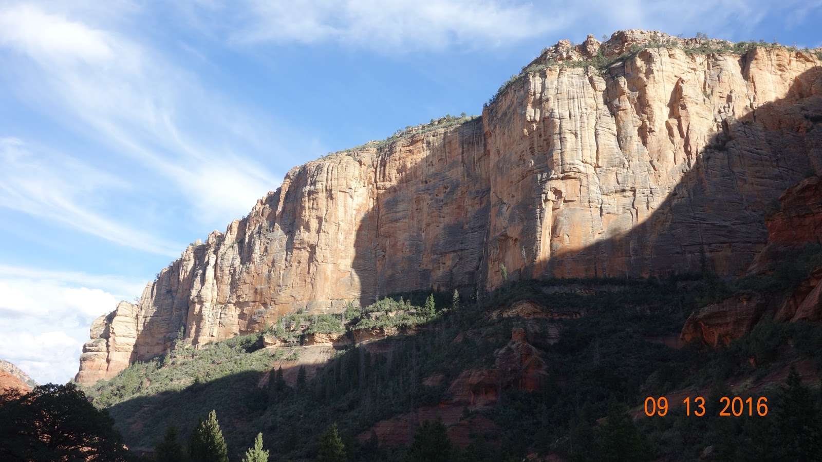


Another hike, this one up Boyton Canyon just outside of Sedona. Beautiful area which I love to hang in. The next pics will be hanging in the sky over it on my wing.

Over the Boyton Canyon area near Sedona Az. Looking toward Flagstaff and the San Francisco Peaks in the distance.

Looking into Boynton Canyon from about 11 000'. Finally a good day off Mingus 23 miles to the west of here.

Looking out to Sedona from same spot over Boynton Canyon. Airport is usual landing zone for Sedona which is on top of the mesa to the left of the pic.

This is Mormon lake to the east of Munds Park on Interstate 17. I finally climbed high enough to make the move for Munds Park after about 2 hrs. of flying around Sedona.

Was trying to make it to Meteor Crater to the east but only got as far as Ashurst Lake, where this pic was taken on a time lapse night shot with the lights of Flagstaff reflecting of the clouds below. The Milky Way above. I found it on Google Earth and Print Screened it. 46.5 mile flight.

Camp on Mingus Mt. Beautiful spot but bring water, there is plenty of firewood but no water.

Good day at Mingus got to 13600' with Ole showing me where to get high. South East winds so headed up to the northwest toward Ash Fork on Interstate 40. This is looking back at Mingus Mt. from Chino Valley.

This was taken from above Big Black Mesa as I got high over it after heading up the Big Chino Valley to the NW of Paulden. Ash Fork is about in the middle of the photo. The San Francisco Peaks are in the right distance. I was topping out around 13000' in the better thermals and pushed on up toward Seligman on I40 to the west of Ask Fork . Flew right over Picacho Peak on the way but got no lift off of it. Halfway from there toward Seligman out over the flats I climbed to 13K again.
This gave me the altitude to make it to Chino Point just beyond Seligman which sits at the south end of the Aubrey Cliffs.

This weather radar tower sits on Chino Point. I flew right over it and debated with Sharon if I should continue on up the Aubrey cliffs. But the winds were still SE and the cliffs face mostly west and I know the road at there base to the west is now on a big private ranch and the rancher has basically locked the hanggliders out of flying Chino Point.

I got to 12500' about a mile north of Chino Point but decided to not risk landing behind a locked gate on private property so headed out to the NW down Hwy 66. This photo is of the Aubrey Cliffs as I'm heading out to the hwy.

Looking more to the north to the break in the cliffs before it continues on to the Grand Canyon.
The northern rim of the canyon is in the distant left of this picture about 25 miles out. I made it 75 miles in 4hrs. 30 mns. with a max alt. of 13600' at Mingus on this flight.
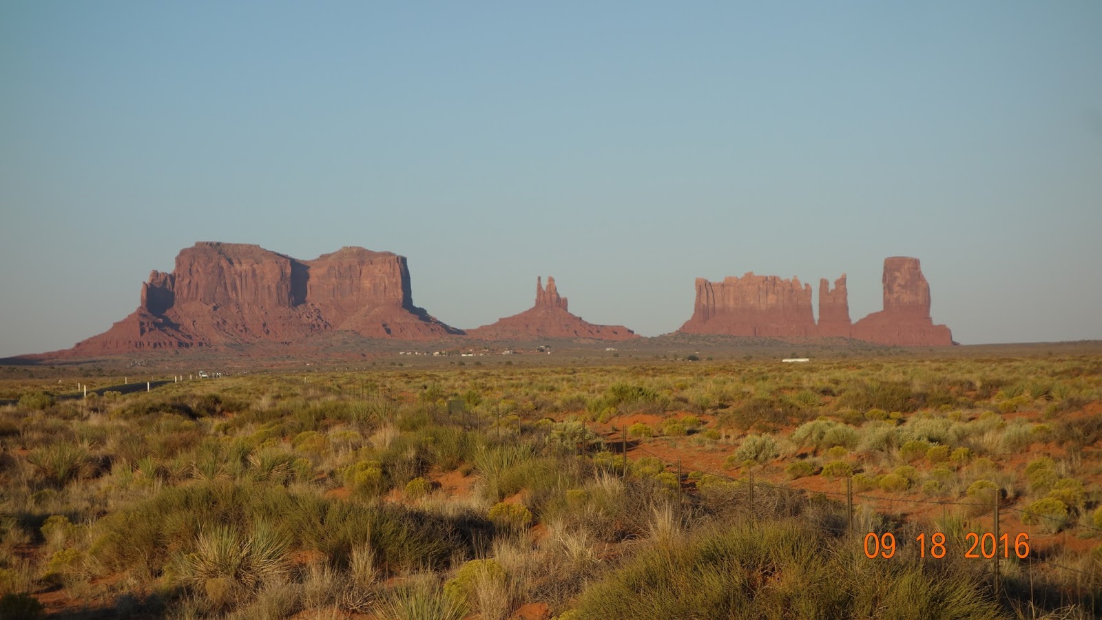

A couple shots of Monument Valley as we drove through on the way to Muley Point a flying spot above the San Juan River in southern Utah near Mexican Hat.


Off of Muley Point looking over the Goosenecks of the San Juan Rvr and out toward Monument valley. I didn't fly as the winds were really lite and I figured it would be a quick sledder down into hell.


Instead we went to this site up west of Monticello called Abajo Peak where Sharon said she had been before with Lisa V. The winds were coming in from the west but there is not much for landing zones on that side of the Mt. It's an early morning east facing site because of that but is very beautiful and somewhere I hope to fly on another flying adventure.
We headed toward Salt Lake after this where Sharon hung out with her relatives and I headed back to California. It was a fun trip of flying, site seeing and hiking, thanks for hanging with and driving for me Sharon, hope you had some fun too.
