Tales and Images from my point of view, Enjoy!
( click on images to enlarge)

Saturday, August 1, 2020

Roping Tornadoes. High Adventure In The Sky

9 days after setting a personal best distance flight, I am back in the Owens Valley for more. There are only so many days of prime time weather during any given season. Late June to mid August is the best.

Our driver Jay declared he had seen 2 tornadoes on our last trip, which of course were only very large dust devils. So now we humorously refer to what we do as "Roping Tornadoes".

Jay didn't make it for this trip so Willy, Reavis and I decided to take turns driving for each other. A full eight or nine hr. day in the sky usually is enough to satisfy our skytime quota for a day. And gives the muscles a chance to rest before the next flight.

I drove for them the first day as I got in late the night before after the 400 mile drive down there.  Willy is trying to break the out and return world record and Reavis is easy going enough to take whatever the day is giving. He tried for an out and return also.  Being on a para glider makes it challenging though as the Owens is usually pumping with south winds all day long.

I drove up to Bishop and parked by the river under a pair of big cottonwoods and concentrated on reading a book and eating, in between dips into the cold water to cool off.  Willy got his out turn point and Reavis turned around at White Mt. We had good radio communications at all time on the 2 meter ham radios we use.

The day over developed with virga and gust fronts picking up about 5pm,  which shut them down.

The next day was forecast to have SE winds around 20 for the whole day across the area with a bit less overdevelopment. I thought it sounded great. Reavis decided to drive as 20 is a bit strong for para gliding in the Owens.

Walts Point google earth screen grab.  On Horseshoe Meadows Rd. at 9140' facing east toward the morning sun.


Looking east from above launch. Owens Lake which is now dry since LA bought up the water rights to grow the city years ago. The original flights in the early days of the sport began from the Inyo Mts. east of the lake. This was before the equipment evolved along with the learning curve which has us launching now at 9:30 in the morning instead of waiting till later. The canyon in front of Walts is perfect for channeling the mornings heat into nice soarable thermals which take us high and on our way.

I launched around 9:40 and climbed out quickly. Willy joined me and we topped out very high for that time of day. He was going to join me going open distance as the SE strong winds would make it to difficult for a return flight.


 This is another google earth screen grab depicting the view when I topped out near 14k (14000) ft. less then 2 miles behind launch. clouds were forming on the peaks and we headed right for them. pretty close together.  An epic start which is rare that early.


I was not quite over Mt. Whitney in elevation but this depicts what it looked like as I cruised by. Willy got a bit closer.  I was too concentrated on setting a new site record and didn't think till later to take a few pics. Wish I had we were  high and deep in this area which would have made for some beautiful shots.


Looking north up range and valley. We fly the Sierras usually for a couple hours and then cross over the valley to the west facing slopes of the White Mts. seen in the right distance.


The view from Tinnemaha Pk from 15+k where we usually try to get high and cross the valley on an angle so we can make use of the SE winds to go fast. We try to come in on Black Mt. which is visible in the right middle past Klondike Lake just north of the town of Big Pine. Then we climb out and fly the rest of the White Mt. range to the north.  At the end of which you are close to 100 miles out from launch.

I made it across easily this day. Willy got low behind me and was out in the valley trying to climb over the volcanic cinder cones. He succeeded for awhile but landed near Bishop. Reavis picked him up and they were on chase together soon there after.


This is from my InReach track log over Black Mt. where I got stuck for awhile. Each of those dots represents ten minutes of time as that is the interval it is set to transmit my location.  Wasn't really trying to draw a few triangles, just trying to get high. Which I finally did. I will link to my InReach tracks page at the end.


Down the White Mts. from over Black Mt. The most southern peak of the range. The whitish peak at the north end is Montgomery peak, beyond it you are in Nevada.  On this day there was good lift with clouds marking it but SE winds coming over the top creating a turbulent layer of air at around 12k. The guys had expressed encountering this the day before also. It isn't really a problem but it can tire you out when you have to give continual correction to your wing as it gets thrown about.   I played it smart staying below this turbulence till the very end of the range where I climbed to around 14k and crossed to the north side of the valley and into the convergence area that develops there.

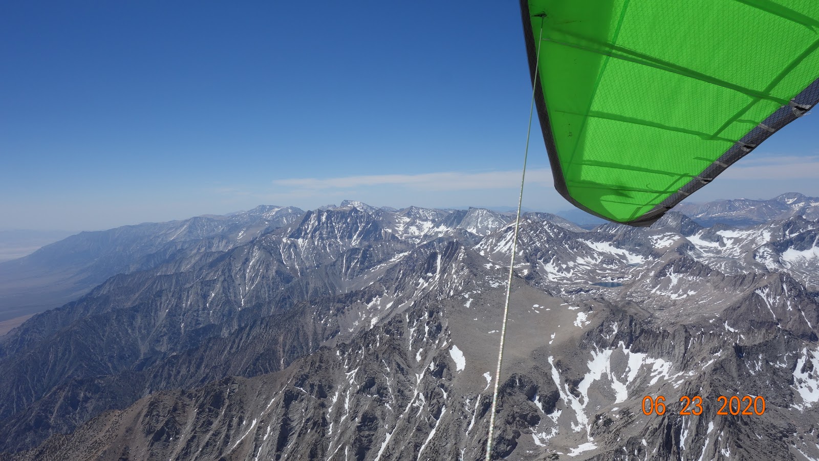
Once there I topped out at 17354' and with the SE winds pushing me along toward beautiful clouds, I put the peddle to the metal,  gliding between roping tornadoes at 65 to 70 mph.  Every day we fly is similar in some respects but also unique in others. The thermals and convergence lines set up in different areas and the winds blow in different directions. With strong SE winds the best way to fly is NW, down wind if you want to go far. The clouds which are just tops of thermals where the moist hot air rising in them hits the dew point and condenses mark the lift lines.

On this day that line was out over the Walker Lake Valley, so that's where I went. Big fat cumulus clouds with dark bottoms signify the strongest lift. That's where I went.

Right in the middle I hooked into a screamer taking me up at 1400 fpm. It was so big and smooth I left my VG (variable geometry) pulled full on.

 I could see virga  or rain falling ahead to the NE and also NW so knew I would have to thread the needle between these areas to continue on. The guys are coming around through Mina and Luning trying to catch up with me. We have excellent radio communication.

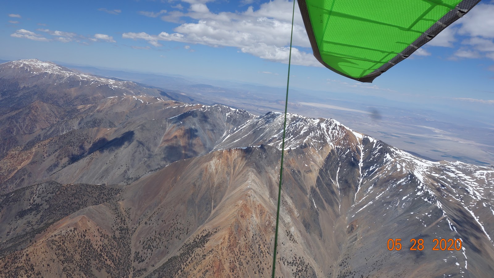
I come in on the Wassuk Range north of Mt. Grant and without any clouds in the area. Diverting here to avoid the OD on the eastern side of the Lake. There are clouds forming up near the north end away from the OD so I work my way down the eastern slopes till Bald Mt. where I take these shots.


Walker Lake looking SE. The nice cloud in the center is where I topped out before gliding most of the way here along the range. Mt. Grant the dominant peak is under my wing tip. Hwy 95 is at the bottom along this side of the lake. The wind is blowing straight up this canyon producing nice smooth lift. I climb out with the local hawks who flash me their talons telling me this is their territory. I return a hand claw sign and show them some teeth.  They respect size and attitude so back off.


 Mt. Grant with virga to the west coming off the Sierras.

 I climb to 13500' on Black Mt. east of Schurz. There is a line of virga on the Desert Mts. to my north and one to my west on the Pine Nut Mts.  Most of the Yerington Valley is in shade, with an area of sun at it's northern border. I head straight for it climbing in smooth convergence lift as I glide across the valley. I blow through the gap between the lines of virga getting snowed on for maybe 30 seconds. Then out and away from it.

 Over Churchhill Narrows I find smooth lift to about 12 k. The guys are below on alt 95 Hwy and head for HWY 50 at Silver Springs. I have it easily on glide. I am headed for the big dry lake near Stagecoach but divert under a cloud at Table Mt. and take it to the top near 14k.

From this altitude I can see the Reno Valley and points NW and it is all in sun. I am about 208 miles from launch its just after 5pm and if I can get to the sun and make a run I feel the site record of 252 miles is breakable.

Only problem is the Flowery Range in front of me is being enveloped in solid virga, so I divert to a gap to the west over Virginia City, to continue on. I know I have got to get around Reno Int. airport so this seems a good move.

I clear the Flowerys easily behind VC. Gliding out to hwy 395 near Little Washoe Lake. I'm sinking out thinking I may have to land soon, then catch some lift and start moving with it toward the Carson Range and Mt. Rose.

The virga has pushed into the eastern areas of the Reno Valley with the cool air pushing the heated valley thermals up and out. It feels like a glass off. Rising air everywhere on the western side.

I move toward Hwy 80 and Peavine Mt. NW of Reno thinking if I can get over it I may be able to outrun this squall line.

It didn't happen I got to the end of the Carson Range and then fell out of the sky quickly, in a flush bowl cycle.

Landed safely if somewhat imperfectly along the Truckee River just east of Boomtown.  232.08 miles from launch. 8hrs. of skytime. 21 miles short of setting a new site record. The thirty minutes I spent at Black Mt. would have made all the difference, at this point of the flight. But that's how it goes.  The day was magnificent.  I will be back to rope me some more tornadoes. and give it all I've got. Thanks to Reavis and Willy for coming out and playing the game. True sky brothers are hard to find.


Bridge at Truckee River and I80 at Boomtown behind.  Link to my InReach page.  https://share.garmin.com/highhuber      You may have to edit the dates page to separate this flt from all the rest. 7-26-20 between 9am and  7pm should do it.

Thursday, July 23, 2020

Owens Valley Personal Best Flight

66 yrs. young. Can this body still push the limits of endurance and effort. A trip to the Mecca of hang gliding is a good way to find out.

Willy Dydo who is 35 yrs. my junior at 31 has similar drive and the same (Go For It) attitude so we make good flying brothers.

The weather looked promising with a low pressure system parked over the state, bringing in instability and cloud streets marking lift.

Some para glider pilots show up also so Willy hooks up with them for the first day of flying on Wed the 15th of July.

I drove down the day before and decide to rest up this day as I want to be completely fully charged for Thursday which I figured would be the best day of the week.

Wed. over develops and nobody goes real far maybe 65, 70 miles.

That night Jay comes up to drive for us so we are good to go long the next day if conditions warrant.

It's not particularly a good day of flying for the Owens Valley and after crossing low to near Flynns launch east of Bishop I can't hook into enough to keep me airborne so land after 70 miles. Eric,  one of the para gliders makes it over the Whites and lands a few miles north of Basalt for around 110 or so. Willy got flushed off the Sierras early, getting maybe 40 miles.

Friday the 17th feels very similar to the day before.  Reavis Sutphin-Gray joins us for it. He is pushing his limits on his Enzo3 para glider going for a 200 miler. I feel this day has a lot of potential if we can just get out of the Owens Valley of California and into the outback of Nevada. The Sierras have been over developing every afternoon so being in Nevada out of the Owens gives more opportunities to avoid OD, and continue flying.

The beginning of the day is very similar to the day before, good enough lift to progress down the range but not a lot of altitude to go fast.


 Mt. Whitney, highest point in the continental US.


Looking north up the Owens Valley from same area. Burn scar is from a couple years ago when the TFR (temporary flight restriction) shut us down.

Willy pushes hard again and is soon scratching low with little options. He will be on the ground before Big Pine.

Reavis, Carter Crowe,on para gliders, and I are playing it patiently making similar progress.  Eric the other para glider who went long the day before falls behind us. The para gliders have excellent sink rates and seem to float along like soap bubbles in a breeze.

They climb out at Tinnemaha Mt. and begin their crossing of the valley to the White Mts. but soon abort and come back. I missed the climb there and continue to Birch Mt. a mile further. We are soon all scratching along the lower hills north of Birch.

I have flown this line many times so when we don't find anything real good I blow across the canyon at Big Pine Creek to an area I usually skyout in and leave them behind.

I climb to 13300 ft. at Round Mt. and decide to cross to the Whites. A similar line as the day before in similar conditions,but a little higher.  SE winds around 18 blowing in the valley, and I am losing altitude quickly.

Not wanting to repeat yesterdays outcome, when I hit some lift just SE of Bishop I decide to keep turning in it, aborting the crossing.  I'm slowly climbing and drifting NW up toward the Owens River.

The Volcanic Tablelands from the Glass Mts. begin rising just north of the river and the lift typically gets better in this area.  I push hard up and over it getting down to 6000' before hooking into something solid.  Yeeha, I rope that thermal and ride it up a few grand and continue on.

Everyone else made the jump and eventually land along the base of the Whites. Reavis getting the farthest, landing about where I did the day before.

The winds begin shifting to SW as I get up near Chidago Canyon Rd. So I go with it toward the north end of the White Mts. Coming in on the SW flanks of Mt. Dubois at Queen Dicks Canyon.

I climb to 15800' or so and report back I have the altitude and am soon to be heading out into Nevada.

Willy, Carter and Eric are left at the park in Bishop, and Reavis and Jay are on chase after me shortly. I can see the SE winds are pushing the clouds over the tops of the Whites so I play it cautious skirting around Montgomery Peak and cross to the north side where I usually find abundant lift.  Clouds are forming in the area and I beam up when I get there.


Here's a great shot looking south, White Mts. on left, Owens Valley, Glass Mts right, with Sierras behind over developing.


Mono Lake and the Sierras with OD building


 Walker Lake to the NW. Excelsior Mts in middle, with Marietta Mines area below my wing tip. I continue on the path my wire is aligned with.  I'm in a convergence zone, two different wind directions, in this case SE and SW coming together which creates an uplifting air mass. That may sound religious to you, we as pilots looking for the eternal high are always elated when we can enjoy the heights along these areas of the sky.  The cloud streets are setting up showing me the way and no priests are there telling me to follow them, just a passion for flight and a desire to remain, tasting the sky.


 Last look at the Whites, before heading north.

I follow the streets of clouds to the Gillis Range east of Hawthorne.  A sky junkies dream come true. A south tail wind pushing me along, between 13 and 18k.  There are areas of virga in the clouds to my west as they build and I am running fast trying to stay ahead of it as they move out into Nevada.

Up near the Rawhide Mine area at 175 miles out the shading from the cloud street has become 100%. I hit an area of sink so bail to the sun soaked ground to the east of the mine. Unzipped and looking for a good place to land I push it into a bowl area that looks promising for thermal development.  I find one and crank and bank back to 16000' ft. Alright, another helping of sky time is mine.

Reavis and Jay are in Gabbs and I send them up to hwy 50 where they tank up at Middlegate on snacks and gas.

I head for Fairview Peak more NE as the shading on my path north doesn't look good.  Find a liitle lift there, nothing solid so move across Hwy 50 to the Clan Alpine Mts. southern flanks.

Get low for a bit but find lift and massage it up to about 10k. There is a dying storm to my east on the Desatoya Mts. that is still pumping out some virga, but also lift along its western edge. With clouds forming under it.

I'm at 206 miles out and topping up at 13k when my flight instrument completely shuts off, out of power.  Bummer.  It's approaching 7pm anyway, there are no clouds over the northern higher reaches of the Clan Alpines where I was intending to go.  I know the site record flight I wanted is going to allude me this day but my personal best has already been broken and the day was fantastic. I have no regrets.  I glide into the Edwards Creek Valley and land gently at the Clan Alpine Ranch. 212.25 miles from launch at 7:11. 9 hrs. of skytime.


Looking ENE maybe 45 mns. after landing.  New Pass Peak in left distance. Reavis says the para gliders have been flying it..... Well  maybe someday!!


The northern portion of my track.

Saturday, July 11, 2020

Independence Day Flight Report 2020, Walt's Point CA.

A fun extended weekend trip to the Owens over the 4th of July.  Not a  great forecast for epic conditions, just a let's go and see what we get, and have a good time trip.

Willy Dydo and his buddy Jay to drive and Darren, and another pilot from the Reno area and myself made up the crew.  I drove down Thursday the second and we all flew Friday.  Not very good conditions at all.  I was the only one to make it to Lone Pine airport, which is only 8.75 miles from launch.

Willy was flying his Alpha training glider and Darren was on a Falcon, Willy landed at the Pheasant Club LZ off Horseshoe Meadows Rd and Darren at the bailout at the foot of the Sierras a couple miles short of it. The other pilot who's name I forgot also landed in that area.

I hadn't gotten a lot of sleep the night before, after driving down that day so wasn't really looking to go long anyway.

The next day was the 4th of July and after a good nights rest we gave it another try.  Willy, Darren and myself with Jay driving. The other pilot left to go home after his flight the day before.

Willy decided to fly his T2C 136 and try for a out and return flight. It didn't look like a record day to me so I wasn't expecting anything great, but being in the Owens Valley you never know what the day could turn into as conditions can change quickly.  Here's the pics and story of how it unfolded.


Walts Point launch. A few other pilots from the Reno area showed up also.


Darrens Falcon. Mark from Reno's T2C. A Moyes RX Pro, behind my Laminar. Willys T2C, and Spike's rig and T2C with the bag still on it.  Mark's launch got out of shape quickly I guess. I had already left the area. He stalled his right wing, clipped a bush, turned 170 degrees and pancaked below launch a hundred ft. or so. He was unhurt but the wing took some damage. I heard later he had the nose high and didn't point it down the slope and get it moving before leaving the ground. An expensive lesson.

Willy tagged Bartlett for his out and return while I was still trying to get some altitude to continue down the range. He continued up the range toward Whitney Portal low while I patiently waited for the day to turn on.  It was slow in starting but I was able to maintain around 10k as Willy got ahead of me about ten miles.  My glider is small by design, 13.2 meters/sq. or 142.5 sq/ft. It's not a 50 to a 100ft up per minute climb beast. I got it specifically to break the Walts Point, open distance site record, in big conditions which the Owens Valley is famous for.  

Once conditions hit 300fpm it climbs great, when they are 1000/fpm it truly shines because with my weight on it, I hook in around 230lbs. it's easily controllable.  I can thermal it with full VG but usually let it off to half or a quarter for most thermals. If they are ratty and turbulent I let it off all the way and rock up and let it do it's thing with minimal inputs, take a drink of water and listen to the vario sing its song as I rocket skyward.  

When it comes time to glide between thermals I pull full VG (variable geometry) for those who don't know the term.  Our gliders have a central cross bar inside the sail, which connects to both leading edges of the wing.  Pulling the cord straightens this cross bar where it is hinged in the middle and pushes the leading edges forward, tightening the sail.  The gliders performance is greatly improved by doing this, but it's handling suffers some what.  We launch and land with just a bit of VG on for the best roll control and a good flare break when we come in to land.  Most beginning gliders have no VG to mess with. But once you know the basics and want to put down some miles you move up to one that does.  You can see this cord in a lot of Youtube videos. My channel is here https://www.youtube.com/user/highhuber  if your interested. Some of the videos have the music silenced out due to property claims, but most of them still have it.


Willy made it across the valley to Black Mt. eventually after reporting himself real low near the volcanic cinder cone in the middle.  I was on course maybe 15 miles behind him at this point not getting real high, barely breaking 12k, or 12,000ft. which is low for crossing the valley.  The winds were holding SE fairly lite and there were no clouds marking lift anywhere. Just a stable mediocre day in the Owens Valley for putting down some miles.  I decided to just hang on the Sierras and continue up toward Crowley Lake, which you can see here in the pic. Hwy 395 follows along their base all the way to Reno and beyond. Willy had landed at this point in Hammil at the base of White Mt for 80 miles beside hwy 6 north of Bishop. 

 I'm at about 80 miles out here and thought I would just keep heading for Mammoth Mt. which you can see in the far left of the pic, just before the snowy mts. in the background which are the Ritter Range. Mono Lake can be seen in the right distance above Lake Crowley on the other side of the Glass Mt.s  Yosemite Valley is behind the Ritter Range to the West. I had never flown this direction before from Walts, and this was why I did so. Just to try a new route seeing as how the site records were safe from our endeavors on this day, due to the poor conditions.

Darren landed his Falcon in the bailout again and Jay reported he was taking him back to launch for a reflight. That had been a few hours ago and we had not heard from him. Willy and I had talked a few times, he knew where I was headed and I knew where he had landed. We are both using InReach sattelite  transmitters so Jay can easily keep track of us with his smart phone, as long as he has cell phone coverage.  No worries of being found at the end of a long day.


This is looking back at Bishop CA. from the same spot. Black Mt. in the left middle distance behind Bishop.  I'm getting high here, topping out at 16.3k and encountering the SW winds blowing over the Sierras.


Looking south into the beautiful Sierra back country.  Same location as I top up. Red Mt. below, Hilton Lakes center right. Rock Creek Rd. and lake left. 


Looking out across Crowley Lake to the Glass Mts.  I have flown them and flown over them before so with the SW winds blowing me off the Sierras, I decide to fly over there, get high and reconnect with Hwy 6 near Benton.  As I am crossing the ground winds turn on and big wind lines form on Crowley Lake from the west. I'm flying above most of it but know when I hit the Glass Mts. I will probably get some good ridge lift to work along with thermals to top out over them with enough altitude to glide over to the north end of the Owens Vly near Benton. The pic is a little tilted but you can figure it out.


I did just that. Got to around 13k on the Glass Mts. bailed over the back and landed near here after not finding much else. That's Montgomery Peak in the background. North end of Benton in the right distance. A fun day flying for almost 6hrs. and covering 96 straight line miles. The guys got to me as I packed up. We had dinner in Bishop at Whiskey Creek restaurant and caught the fire works in Independence Ca. on the way back to camp.  No other way I can think of social distancing even comes close. Find your passion and follow it, that's my advice.


My InReach track Log. Check it here on any given day and follow along on my flights. It is uploaded almost real time but is about ten minutes behind. click on the blue dots and hit (more) for altitude and speed and location.  https://share.garmin.com/highhuber   Use the Map Filters on the left to view specific dates, or the last seven flights or whatever. Hit View All Tracks to see them all.

Monday, June 29, 2020

Walts Point Flight and Earthquake Experience 6-23 and 6-24-2020

Me and Willy Dydo made another trip to the Owens to get some extended airtime. Willy drove over Sunday night from his base in SantaBarbara as Monday the 22nd looked good for an out and return flight.  I drove down Monday and told him I could retrieve him if he didn't quite make it back to Bartlett, where he had left his motorcycle..

He got a few miles farther then Owen Morse on his out flight and got high again just west of Benton, but he diagonalled across the valley instead of using his altitude to cross straight over to the White Mts.. He didn't get up and ended up landing in Hammil. I picked him up with no problem as he purchased an InReach and texted me his location from it.  The rest of the adventure is from the next 2 days.

We went up Tuesday leaving Willys motorcycle and my car at Lone Pine airport. Willy was going to do a flight to Mt. Whitney and then land at the airport and chase.  He made the airport but not Whitney as the day hadn't turned on when he launched at 10am. My experience was a little better. I launched around 10:15 and climbed out easily to 13k over Wanoga Pk. This pic is from somewhere up the range looking south after I got established over the top. Near Onion Valley I believe.  I made good progress staying high and moving fairly fast.  Clouds were forming here and there marking strong lift. I caught a boomer in front of Birch Mt. and rode it to over 16k and headed across the valley toward Black Mt.  Was still above 13k when I crossed hwy 395, and had nice clouds forming on Black to guide me to the lift.
This is looking west down Kings Canyon in the same spot as the last picture. 
Off the end of the Whites where I had good solid lift and stayed fairly high the whole time. Mono Lake and the Sierras in the distance.  It took me 4 hrs. to do the first 100 miles but being only 2:15 I had plenty of daylight left to go for 155 more. 
Looking down the White Mt. Range and the nice cloud street marking nice fat lift down it. Some days the flying is better then others.  Some days the first half of the day is better then the second.  On this day the afternoon flying was ok. But the day started overdeveloping big time over by Bridgeport and Sonora Pass.  This OD as we call it turned into a monster anvil shaped thunder head and although I was in no danger of being caught in it's lightning and gust front it eventually grew so tall it started shading out my path.
Looking east into Nevada from near Boundary Peak. Nice dark bottomed clouds marking lift.  Only problem was eventually they became saturated with moisture and started dropping virga or rain and shut down my path toward the Toiyabe Range.  The winds were SE primarily also and I originally was going to fly toward Fallon down the west side of Walker Lake. But as the storm near Bridgeport grew it killed all the clouds on that path so I made a turn and headed up toward Luning instead. I was flying cross wind but staying high mostl of the time.  Hit 18k+ at one point crossing under a big fat boomer or 2.  My InReach said I got 20K but this is incorrect.  It said I got 50K on my last flight in the Owens by White Mt. so something is up with it.  Willy and I had perfect radio communication. He was sitting in Mina waiting to see which way I was going.    
Eventually with more virga building on the Toiyabe Range I headed over to Gabbs and landed, after 7.5hrs and 166.14 miles.
My InReach track log.    So the next day I told Willy I would drive for him. He wanted to try for another out and return flight as he had to be back in Santa Barbara in the morning.  He got off and climbed out quickly to 12K then headed out to tag Bartlett so on the return he could cross paths with his track for a legit run.  Just as I got into the vehicle and was reaching for the door the mountain started shaking and rocks started falling making a lot of noise.  I jumped out of the car to see if I needed to run from being squashed by a piece of granite.  But nothing fell right at launch. There were massive avalanches of rocks down into the surrounding canyons which raised large clouds of dust into the sky.  The road was completely blocked just past Walts Point but I was able to make it down the mt. to the valley just barely.  Some other vehicles in front of me had to remove rocks in some areas to make it passable. Other rocks were the size of cars which luckily did not fall on anyone.  The day was ODing and Willy got shut down just past Big Pine.  That was all the flying for this trip to the Owens Valley.   We are going back for the 4th for more.

Sunday, May 31, 2020

Walts Point Flight 5-28-20

I and Willi Dydo met our driver Chuck at Lone Pine Airport at 8:30 that morning. Forecast for the day looked promising for a good early season flight in the Owens Valley and beyond. Good lift and  SW winds of moderate strength predicted to remain constant for the whole day. Willi and I flew the day before along with Doug Englecook who we hitched a ride to launch with. That day was not as favorable for XC flying so we both did out and returns and landed at the airport.  I had driven 425 miles to get there the day before and hadn't slept much that night so a little check ride of 2 hrs. was fine with me. Willi crossed over to Mazourka Pk. and came down the Inyos before landing in Lone Pine.
Walts Point on Horseshoe Meadows Rd. 9135' on the eastern face of the Sierra Nevada Range. Driver Chuck in chair and Spike, a southern cal pilot. Willi is hiding behind his wing.

This is looking over the back near Kings Canyon National Park. About 22 miles north from launch after I got high.

Same spot looking south toward Mt. Whitney and Walts Point launch at the far end of the visible range.Willi was flying near the base of the range the whole time but staying almost even with me for awhile anyway.

This is after I had crossed to the White Mts from Tinnemaha Pk where I climbed to 16600' before making the jump across the Valley. We launch the eastern Sierra mid-morning to take advantage of the rising thermals created by the morning sun, after a couple of hours we cross to the western faces of the White Mts. on the other side of the valley. I made it easily above 11000 and started climbing from there. I'm around 75 miles out in this picture. The air was a bit turbulent at times as we were flying between 2 massive high pressure ridges dominating the weather pattern. But the thermals were strong .

I found lots of turbulence at the end of the White Mt. Range and as I wasn't high enough to go over the back of them toward Montgomery Pass on the usual route because the winds were rotoring over their flanks strongly.  I flew due north across the valley to some building clouds marking great lift coming off the valley floor. I skied out to over 17k and got this and the next pictures. That is Mono Lake and the Sierras in the distance.


Same spot looking down the Owens Valley from its north end. White Mts. on the left Sierras on the right. Cloud streets building on course and I am a happy camper. Willi at this point was around 15 miles behind me and he found turbulence at the turn in the range also. he flew out and landed near the last crop circle in the lower right of pic for around 97 miles.
Montgomery pass from same spot looking into Nevada with decent clouds marking lift.
I got a little greedy at around 140 miles out thinking I needed 115 more miles to break the existing site record with I figured 3.5 hrs. of  good soaring left in the day at 4pm. Skipped a climb I should of in hind sight taken and couldn't find the lift under the clouds on the southern flanks of Mt. Ardivey.  Had to come back out and land here at 4:30 for a flight of 153 miles in 6hrs. 13 mns. of sky time. No worries the season has just begun and the quest goes on. The journey is the joy driving this old boy, The records will fall when they may.

Wednesday, May 31, 2017

Slide Mt. to Surprise Valley Flight Report


 Matt Dakin getting ready to go. He and I drove up together, not that bad a drive with Freeway for most of it. We left Calistoga where I picked him up at around 7am and got into North Lake Tahoe about 10.   Lots of snow in the mountains this spring and lots of Reservoirs over capacity.  Washoe Lake is right up against Hwy 395 but the bailout LZ is still dry.


 Steve Grattan and another pilot I didn't know. Maybe 10 hangs total flew. Matt said somebody broke an arm in the bailout when he was there.  I think it was the first pilot off the hill who was on a topless Moyes and said it had been 13 yrs. since his last flight.  Not a fun way to begin again.


Lake Tahoe as I climbed up over Slide Mt. Radio was giving me the weather stations and I had to pull it out and get it back on channel after I topped out around 12k. and glided back to Mt. Rose. Also turned on my InReach Sattelite tracker at this point so it doesn't show my takeoff at Slide. It's set for 20 mn. gaps between track points by me, which seems good enough for flying purposes. I didn't launch till almost 1 but the winds were predicted to be SE for most of the day  so I was in no real hurry, as others were sinking out, to go.


Lake Tahoe from where I climbed out before crossing over i80 to Peavine. Mt.  Lots of virga and high clouds blocking the sun but the day had lots of promise. Winds were mostly in the 8 to 14 mph range. Predominantly S at base but lower down SE to SW depending on the terrain.


 Peavine Mt. from same local as previous shot looking north across i80. I flew straight to Peavine and by the time I got there those nice clouds were right over it and I hit strong lift to 14500' or so.  The Sierras were over developing with virga falling everywhere so knew I had to stay away from them. I flew over Cold Springs Lake and town which is just to the left of Peavine and came in on the ridge behind it a bit low.  After a few turns I decided to ridge soar up it's eastern facing flank as my flight instrument was showing SE winds around 14 mph which I figured I could ridge soar till I caught a good thermal.  I gained some alt. but never really hooked up and was slowly sinking down below the ridges top. My vario said SW at this point so I figured the westerlys had pushed into this locale so moved over to the other side of the valley which had a road and good places to put down in.  I caught a thermal, after unzipping and picking out a landing zone, and rode it back to around 10k.  I was only about 30 miles out and did not want to end my flight so soon on this great looking day.


 This shot is about an hour and a half later after I scratched across a hard stretch and finally skied out to base above 16k.  Pyramid Lake to the east looking into Nevada and a soaring pilots wet dream. Around 45 miles out, here, I think.  Nice looking cloud streets all the way to the Warners down wind of me so that is where I headed.  Matt and our driver Mike were ahead of me sitting on 395 and got a visual of me here.


The Warner Range with snow covered peaks ahead and Surprise Valley to it's right.  Beautiful clouds with strong lift over 1200 fpm and big sink between them for super fast glides in the 60 mph range with the south tail wind.  Good radio reception and the guys were staying even with me on Hwy 395 to my west a few miles.  I never got low again after that one hard stretch.  Mostly stayed above 10'000 till getting to the Warners.  Had my oxygen working good which was nice to have as the air was quite cold up high. My camel back line had slush in it but never froze solid so I had plenty of water to drink.


 Last shot I took as I flew between clouds dropping virga. Got snowed on or sleeted on a few times but nothing major. I've had my arms turn white on other flights.  The virga doesn't seem to affect the air to much if you are not right under it where I imagine it can have a strong down bursting nature.  No big cunims to worry about on this day so I was not worried and flew through the snow uneventfully.  16823' max alt. near this point. Cloud base was easily above 17 but I felt uncompelled to find out and risk entering the white room.  I hit max alt. after pulling on the VG at 16500' and crossing under a cloud lifting me at 1250 fpm.

Anyway I was hoping to get up on the Warner Range and at least try to take it to Lakeview but by the time I got there they were covered with clouds dropping snow and rain.  I got to Eagle Peak which is at 9900' above it by about 200 ft. but with no lift to be found and the range in clouds glided out into Surprise Valley and landed along the Hwy.  The guys were on Hwy 299 waiting for my transmission telling them which way I would be going to land.   I could have went more east out into the Nevada back country to extend my flight, but both those guys had to work in the morning, and I didn't feel like ending my flight in the middle of nowhere.

I dropped my streamer low after pushing it to a field which still had some sun on it hoping to get up but no luck and I didn't see the streamer fall over with the ground wind.  It laid over NE to SW but I guessed it had laid over SW to NE because that's the last direction my flight instrument had recorded.

I came in over the highway and just kept going and going at a high speed and knew I was in for some pain or broken metal at least in the tailwind.  I flared with all I had and kept it from whacking but fell on my right shoulder hard and bruised it deeply if not an outright seperation. The glider was fine. A field worker came over and gave me a hand unclipping.  I stood up and tried to shake off the pain but it wasn't going away.  I took off my helmet and hung it on the wires and walked down to the Hwy maybe 75 yards where I took off my harness.  Then I tried to take off the speed sleeve and while lifting my right arm over my head the shoulder felt like it was coming out of the socket a bit.  I grabbed a fence post and knelt down and pulled on it to get it to reseat which it did finally.  I had the use of the hand and nothing felt broke so the guys and I instructing them got the glider bagged and we hit the road for home.  A killer retrieve getting back to Incline Village where we dropped off the driver about 12:30 and headed to drop off Matt in Calistoga around 4am. Home to bed around 5am after a shower and some unwinding and ibuprofen.


The start of my InReach tracklog. I forgot to turn it on at launch as this was my first flight with it this year so it starts from where I did. The points are 20 minutes apart so you can tell how well I'm doing by their distance apart. The slow stretch is obvious in the beginning after I crossed Hwy 395 at Cold Spring


 The end of it in the surprise Valley 7 miles from Cedarville. 146.2 mile flight 1250fpm max lift. 5hrs.30 mns. of SkyTime. Landed at 6:30. One of the best soaring days of my life which could have been 200 miles easily with a little different conditions and without the slow section at the start.   Thanks again Matt for joining me, and awesome driving as always Mike, you rock.

Here's the Delorme page for the track if you click on the track points it gives you my alt. and speed and gps coordinates. This page is in the members section of Sonoma Wings web page under the About heading.  If on any given day someone calls you to get my last position just click on that days track and go to the end and get the info. and give it to them.
https://share.delorme.com/highhuber   Thankyou.